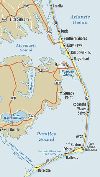
The Outer Banks is a chain of barrier islands off the coast of North Carolina. Often referred to as the OBX. It is a special place, rich in history and natural beauty. It is home to the Cape Hatteras National Seashore, the Wright Brothers Memorial, and the largest sand dune on the east coast (Jockey's Ridge).
Something for Everyone
The Outer Banks has all the elements for a great vacation. Each area has it's own personality. You could choose to stay in a remote ocaenfront cottage (accessible only by 4-wheel drive), or stay close to fine dining and entertainment.
- Beautiful, uncrowded beaches
- World-class fishing
- Fine dining
- Entertainment
- Accommodations for every budget (from camping to 12-bedroom luxury oceanfront homes)
- Great surfing
- Museums and many areas of historical significance
Each Area is Unique
The Northern (4x4) Beaches
The most northern part of the Outer Banks, are known as the 4x4 beaches. Often referred to as "Carova" as this is the most populated "town" in that area. Vacation homes here are available to rent, but are only accessible by 4-wheel drive vehicle. This areas consists of 12 miles of sparsely developed beach where wild horses roam free.
There are no businesses in this area. You must do all your shopping in the town of Corolla.
Corolla
The pavement begins in the town of Corolla. This area has the historic Currituck lighthouse and is characterized by large, luxury homes built since the 1980's
Duck and Southern Shores
Duck and Southern Shores are beautiful residential areas nestled among pines and live oaks. Duck has a quaint village center with shops and restaurants. There is no public beach access in these two towns. There are access points, but there is no parking.
The Central Beaches of Kitty Hawk, Kill Devil Hills, and Nags Head
This is where it all began! Vacationers began coming to Nags Head in the 1800's to escape the hot inland summers. The Wright brothers flew at Kitty Hawk (but that particular spot is now in a town called Kill Devil Hills).
Kitty Hawk
Made famous by the Wright brothers, this is the first town you will pass through when you come over the Wright Memorial bridge from the mainland. Kitty Hawk consists mainly of modest beach cottages, but there are some restaurants and Hilton Garden Inn.
Kill Devil Hills
The most developed of the towns along the outer banks. Along with beach cottages, you will also find many shops, restaurants, motels, and the Avalon fishing pier. A memorial to the Wright brothers first flight is here as well (milepost 8). A national monument marks the spot along with a museum and exhibits.
Nags Head
Nags Head is often referred to as "The grandfather of North Carolina beach resorts". Vacationers have been coming here since the 1800s. They first came by boat across the Roanoke sound and stayed in cottages on the sound side of the island.
Today you will find a wide variety of vacation cottages for rent. You can fish from the Nags Head pier at milepost 11 or from Jenettes pier at milepost 16.
As you leave Nags Head to the south, you enter Cape Hatteras National Seashore.
Roanoke Island
Hatteras Island
As you leave Nags Head and cross the Bonner bridge over Oregon Inlet, you come to Hatteras Island. Hatteras Island is home to most of the of the Cape Hatteras National Seashore. This thin ribbon of sand has miles of open beaches and seven villages (Rodanthe, Waves, Salvo, Avon, Buxton, Frisco, and Hatteras).
There are businesses and rental cottages, but on a much smaller scale than the areas north of the Bonner bridge.
Pea Island Wildlife Refuge
The northern-most 13 miles of Hatteras Island is dedicated to Pea Island Wildlife Refuge. Pea Island is not an island, it is part of Hatteras Island. The only development you will see in this area is the visitors center. There are places to pull off, get out and observe the wildlife.
The Tri-villages of Rodanthe, Waves and Salvo
The villages of Rodanthe, Waves and Salvo are the first developed area south of Pea Island. This area is often referred to as the Tri-villages or abbreviated "RWS". The towns are so close together that it is difficult to tell when you leave one and enter the other.
In this area you will find small businesses, shops, restaurants and the Rodanthe fishing pier. You will also begin to see "ramps" for 4x4 vehicles to access the beach and sound-side areas. Just south of Salvo is Ramp 23 on the ocean-side and the Salvo day-use area on the sound-side.
Avon
Probably the largest town on Hatteras Island. It has a grocery store, several restaurants, a fishing pier, and a large planned community (Kinakeet Shores)
Buxton
Home of the famous Cape Hatteras Lighthouse. You will also find shops, a small grocery store and motel. The island makes a sharp turn to the southwest here.
Frisco
The area between Buxton and Hatteras is Frisco. There are rental homes, camp grounds and a small airport (Billy Mitchell Field)
Hatteras Village
At the southern end of the island is Hatteras Village. There are rental homes, motels, restaurants,and marinas. You can take a free ferry to Ocracoke Island.
Ocracoke
The entire island of Ocracoke is National Seashore except for the village at the southern tip. The island is about 12 miles long and it can only be reached by ferry. Blackbeard the pirate was killed here. The village is a great place for a day-trip. It is small, picturesque and very walkable.


